North-Eastern Atlantic, Mediterranean and connected seas
Tsunami Information Centre


Tsunami hits Greece and Turkey after 7.0 earthquake
On 30 October 2020, a significant tsunami triggered by an earthquake of magnitude 7.0 Mw hit the island of Samos (Greece) and the Aegean coast of the Izmir region (Turkey). The event shed light – once again – on the complexity of warning of locally generated tsunamis of rapid onset which challenged the ability of local authorities and communities at risk to take early action. According to Turkey's Disaster and Emergency Management Authority (AFAD), one of the confirmed victims in Turkey drowned because of the tsunami. This event is a bitter reminder after the wake-up call on 20 July 2017, following the Bodrum (Turkey)-Kos (Greece) tsunami, to increase tsunami preparedness through enhanced sea-level detection networks, education, as well as international cooperation.
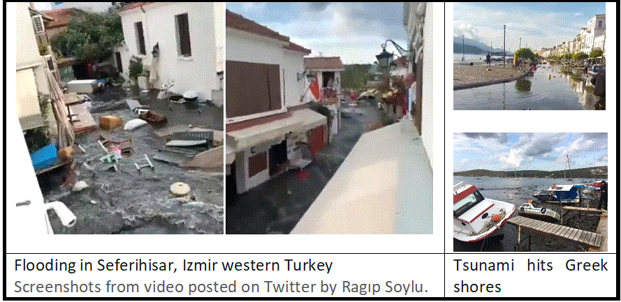
On 30 October 2020, at 13.51 local time (11.51 UTC), an earthquake of magnitude 7.0 Mw struck off the Aegean coast of Turkey, south of Izmir, and north of the Greek island of Samos (37.91 N 26.79 E), with an estimated hypocentral depth of 21 km (USGS-United States Geological Survey). The earthquake triggered a tsunami that flooded the coastal district of Seferihisar (Turkey) and the port of Samos (Greece).
Within 8-11 minutes after the detection of the earthquake, tsunami bulletins were issued to national focal points by the Tsunami Service Providers (TSPs) accredited by UNESCO’s IOC Intergovernmental Coordination Group for the Tsunami Early Warning and Mitigation System in the North-eastern Atlantic, the Mediterranean and connected seas (ICG/NEAMTWS)*. Greece and Turkey were put on “Tsunami Watch” (highest level of alert), while other countries either on “Tsunami Advisory” and/or “Tsunami Information” levels.
According to the Institute of Geodynamics-National Observatory of Athens and the Kandilli Observatory and Earthquake Research Institute of Turkey, eyewitnesses in certain locations claimed that the drawback started within 2-5 minutes after the earthquake, followed by runup within 15-20 minutes after the earthquake. Preliminary rapid assessments show that a runup of 1.8 meters on the northern side of Samos (Karlovasi and Vathy), with a maximum flow depth values of 1.9 meters and 1.5 meters in Akarca and Sigacik, respectively.
As part of the emergency response, text messages to cellphones were sent by the General Secretariat for Civil Protection in Greece 24 minutes after the earthquake and preliminary data show that local authorities (police and port authority) in Vathy ordered people to move away from the coast. Reports indicate that self-organized evacuation took place among the population living in the impacted areas in Greece and Turkey, leading to zero casualties in Greece. According to Turkey's Disaster and Emergency Management Authority (AFAD), one of the confirmed victims of the disaster in Turkey drowned because of the tsunami.
Science contribution to awareness, preparedness
The event shed light one more time on the need to strengthen tsunami preparedness in the region, through enhanced sea-level detection networks, education, as well as international cooperation. One of the main priorities is to increase the awareness of communities at risk and local authorities through communication, evacuation exercises, training, information, preparedness and recognition programmes such as the Tsunami Ready and the Last Mile programs, as it is the case for the Pacific, Caribbean and Indian Ocean region. People need to know what to do in the presence of natural signs (e.g. earthquake followed by rapid sea-level changes), with or without an official warning.
International cooperation
On 12 June 2017 and 20 July 2017, two small-scale tsunami events occurred in the Aegean Sea (Mw 6.3 and Mw 6.9 respectively), the former impacting the island of Lesvos (Greece) and the latter impacting the island of Kos (Greece) and the Bodrum region in Turkey, within a few minutes after the earthquakes. As no timely alert reached the population, the community remained in the hazard area, exposed to high risk.
After these two events, in 2018 a “Tsunami Last Mile” project was initiated and funded by the European Union’s Emergency Response Coordination Center (ERCC), through the Joint Research Center (JRC) to test technologies and procedures to effectively alert local communities in case of near-field tsunamigenic earthquake events. In Kos, a tsunami preparedness exercise was conducted in November 2019, while Bodrum carried out a tabletop exercise involving meetings with stakeholders on tsunami readiness.
On 30 October, one low-cost experimental Device for Sea Level measurement (IDSL) installed thanks to the Tsunami Last Mile project picked up the tsunami signal (4-5 cm) in Kos (Greece), which supported, among other stations in the area, the confirmation that a tsunami had been generated.
Following this last event, a field survey along the Aegean coast of Turkey has started under the leadership of Prof. Ahmet Cevdet Yalciner of the Middle East Technical University (METU) and with the support of Kocaeli University (field), KOERI and EC/JRC (remote). The team works in coordination with the National Observatory of Athens (NOA) that has conducted a preliminary field survey on the island of Samos and will survey all the Greek islands around the earthquake epicenter.
For more information, please contact:
Dr Denis Chang-Seng, Programme Specialist, Tsunami Unit, Technical Secretary (ICG-NEAMTWS) (This email address is being protected from spambots. You need JavaScript enabled to view it.)
*National Institute of Geophysics and Volcanology (INGV, Italy); Institute of Geodynamics-National Observatory of Athens (NOA, Greece); Kandilli Observatory and Earthquake Research Institute (KOERI, Turkey).
NEAMTIC Resources
![]()
This website was developed with the support of the European Commission Directorate General for Humanitarian Aid and Civil Protection.
Developed by Mediatools
The translations provided are automated by Google Translate and therefore may not be accurate. NEAMTIC will not be responsible for the discrepancies of the translated version of the website.