
North-Eastern Atlantic, Mediterranean and connected seas
Tsunami Information Centre


Deadly and Damaging Earthquake in Türkiye and Syrian Boarder, Tsunami-related Sea Level Anomalies Detected in Türkiye
A deadly and damaging M7.8 earthquake hit southern Türkiye at 4:17 local time (01:17 UTC) on 6 February 2023 (Fig 1). According to the Kandilli Observatory and Earthquake Research Institute in Türkiye – (KOERI), the earthquake occurred near the Syrian border at 90 km from the coast. The earthquake was felt as far as Cyprus, Egypt and Lebanon. The UNESCO/IOC Intergovernmental Coordination Group for the Tsunami Early Warning and Mitigation System in the North-eastern Atlantic, the Mediterranean and connected Seas (NEAMTWS) responded to the earthquake. Tsunami Service Providers in Italy (INGV) and Türkiye (KOERI) issued their first tsunami bulletins within 8 to 15 minutes respectively following the detection of the earthquake. Several countries including Albania, Croatia, Cyprus, Egypt, Greece, Israel, Italy, Lebanon, Libya, Malta, Montenegro, Palestine, Syria, Tunisia, and Türkiye were placed on Tsunami Watch. A tsunami ranging from (12-17 cm) was detected on sea level stations following the earthquake around Türkiye.
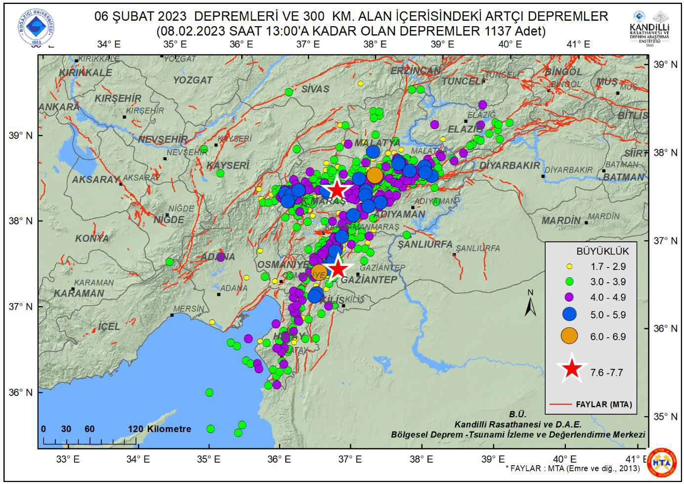
Fig 1: Seismic activity in the 300-km diameter area after the earthquakes by 08.02.2023 10:00 UTC (KOERI, 2023)
KOERI (Türkiye) Tsunami Service Provider (TSP) issued its official first regional tsunami warning message with 15 minutes after detecting the earthquake. KOERI estimated the magnitude of the earthquake at 7.5 MWP (13 km deep located at - 37.18 North, 37.09 EAST). INGV (Italy) issued its first bulletin within 8 minutes after the detection of the earthquake of 7.9 magnitude (Mwpd) (35 km deep at - 37.19 North 37.17 East). In the second bulletin, both TSPs reported that a tsunami had been recorded at three tide gauges located around Türkiye coast. KOERI reported sea level records on three tide gauges ranging from 12 -17 cm (Fig 2 and 3). INGV (Italy) issued the third and final bulletin at 06:02 Z, while KOERI issued its fourth and final bulletin at 09:59 Z.
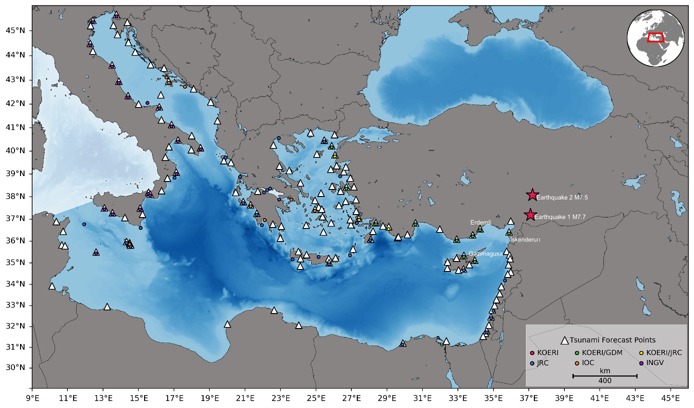
Figure 2. Figure shows the earthquake locations and mareographs. Mareographs with Sea level measurements. Earthquake1 refers to Mw7.7 01:17 UTC and Earthquake2 refers to M7.5 10:24 UTC. Source KOERI
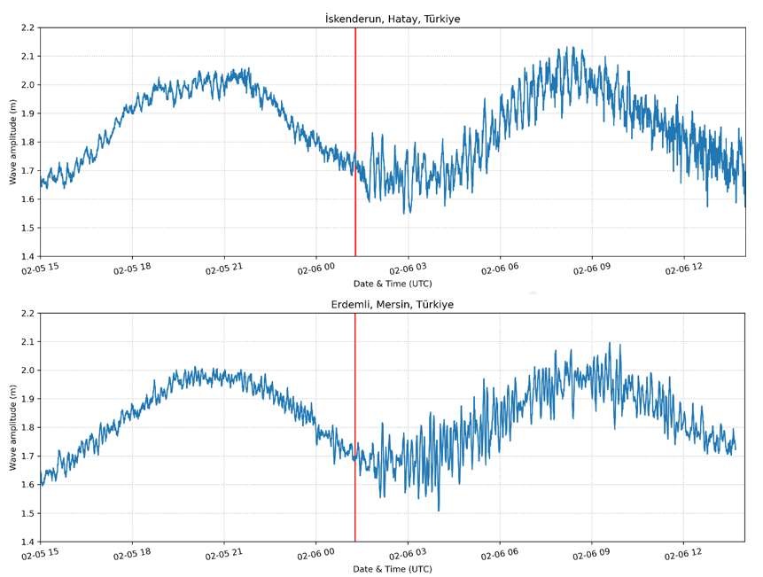
Figure 3: Iskenderun (top), Erdemli (bottom) mareographs. Red line indicates earthquake origin time. Source KOERI 2023
NEAMTIC Resources
![]()
This website was developed with the support of the European Commission Directorate General for Humanitarian Aid and Civil Protection.
Developed by Mediatools
The translations provided are automated by Google Translate and therefore may not be accurate. NEAMTIC will not be responsible for the discrepancies of the translated version of the website.